As Winter Storm Juno begins to affect our towns, a parking ban has been announced throughout Old Lyme from 6 p.m. tonight until further notice. Keep all vehicles off the roads so that they remain open for emergency vehicles and can be safely cleared when the storm ends.
Governor Dannel Malloy has announced that all non-emergency travel must cease on all roads in the state tonight after 9 p.m.
If there is a fire hydrant on or near your property, please help by keeping it clear for emergency use.
The following cancellations and early closings have been announced in Lyme and Old Lyme:
- The Solarize Meeting and Annual Town Meeting have both been cancelled for tonight and will be rescheduled
- The Lymes’ Senior Center is closed for the remainder of the day and will be closed on Tuesday
- Region 18 schools have early dismissal today, all evening activities cancelled and will be closed on Tuesday.
- There will be no trash or recycling pick-up on Tuesday.
The Old Lyme Emergency Operations Center @ 860 598 0120 will open mid-afternoon.
To report a power outage, call 800-286-2000, or text the word “outage,” followed by a space and your zip code, to 24612.
Stay away from downed power lines and call 911 to report them.
Travel will be hazardous. Stay off the roads during the storm.
Your cell phone will be an important tool during this emergency — make sure it is charged.
Exposure to cold temperatures and sustained winds will contribute to hypothermia and dehydration. If you go outside, dress in layers and wear hats, scarves and gloves. Remove wet clothing as soon as you are back indoors.
Call 911 to report all emergency situations
Snow has already begun and will intensify during the afternoon commute.
Snow tonight will increase with rapid intensity at rates of 2-4 inches per hour.
High winds will also be present, gusting up to 60 mph along the coast.
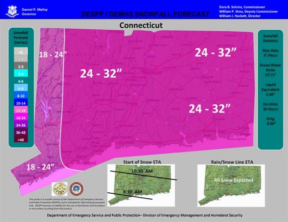
Expected snow accumulation is from 12-25” across the state, with wind gusts up to 40 mph, and the risk of blizzard conditions through 6 pm Tuesday.
Tidal flooding can be expected with tides being 3-4 feet above normal.
Flooding can also be expected in low lying areas around town.
High tides are predicted at 3:04 pm Monday.
Tuesday’s high tides will be 10:15 am and 11:18 pm.
This is the map issued by the state’s Department of Emergency Management and Homeland Security (DEMHS) showing predicted snowfall totals for Winter Storm Juno. It looks like there’s little chance we’ll dodge the snow this time, in contrast to last week when we were let off pretty lightly
Here’s a link to track the storm and another on how to prepare for the storm.